Tetra Land Services is a full service commercial and residential land surveying company.
As active members of the Texas Society of Professionals Surveyors, American Builder’s Association and many local and regional chapters and organizations. We dedicate time, expertise and knowledge to improving our community.
Commercial Surveys – an ALTA/ACSM Land Title Survey
For commercial closings, lenders will usually require a type of survey called an “ALTA/ASCM Survey.” ALTA stands for American Land Title Association, and ACSM stands for American Congress on Surveying and Mapping. An ALTA/ASCM survey is a Boundary Survey that must meet certain stringent standards established by these two organizations.
- Survey existing conditions of the future work site, including topography, existing buildings and infrastructure, and underground infrastructure whenever possible (for example, measuring invert elevations and diameters of sewers at manholes).
- Stake out lot corners, stake limit of work and stake location of construction trailer (clear of all excavation and construction).
- Subdivision (Boundary, Lots, Streets and Utilities.
- Stake out reference points and markers that will guide the construction of new structures.
- Verify the location of structures during construction.
- Provide horizontal control on multiple floors.
- Conduct an As-Built survey: a survey conducted at the end of the construction project to verify that the work authorized was completed to the specifications set on plans.
Topographic Surveys
A topographic survey, or “Topo” survey for short, is done to locate natural and man-made features on a particular parcel of land. The topographic survey is defined as the service preformed to determine the configuration, relief or elevations of a portion of the earth’s surface, including the location of natural and man made features thereon. It is different in that the elevation of the surface of the land is surveyed and represented on the resulting map of the survey.
The elevation or differences in elevation on the surface is usually shown as contours on the survey. A contour line is a line that connects points of equal elevation. This type of survey is used by engineers, architects, planners, developers, landscape architects and governmental agencies.
Elevation Certificates
The elevation certificate is an important administrative tool for the National Flood Insurance Program (NFIP) and an important risk management tool for property owners with buildings currently classified within FEMA designated Special Flood Hazard Areas (SFHA).
An Elevation Certificate can determine where precisely your home is located in relationship to the Base Flood Elevation. You may want to obtain a flood certificate if your property is in a flood zone, and you are considering disputing it.
If your building is in a high-risk area—a zone indicated with the letters A or V on a Flood Insurance Rate Map (FIRM)—the EC includes important information that is needed for determining a risk based premium rate for a flood insurance policy.
For example, the EC shows the location of the building, Lowest Floor Elevation, building characteristics, and flood zone. Your insurance agent will use the EC to compare your building’s elevation to the Base Flood Elevation (BFE) shown on the map being used for rating and determine the cost to cover your flood risk.
The BFE is the elevation that floodwaters are estimated to have a 1 percent chance of reaching or exceeding in any given year. The higher your lowest floor is above the BFE, the lower the risk of flooding. Lower risk typically means lower flood insurance premiums.
Base Flood: The flood having a 1 percent chance of being equaled or exceeded in any given year.
- Base Flood Elevation (BFE): The water surface elevation, expressed as an elevation above sea level, of the base flood. This is the minimum elevation a community must adopt for building standards.
- Flood Insurance Rate Map (FIRM): A map issued by the Federal Emergency Management Agency (FEMA) showing flood hazard areas, BFEs, and risk premium zones.
- Pre-FIRM: Buildings constructed before the community’s first FIRM. Communities might not have elevation information on file for these properties.
- Post-FIRM: A building constructed on or after the date of the initial FIRM for your community. FIRM effective dates can be found at FEMA.gov/FEMA/csb.shtm.
As-Built Survey
As-Built survey: a survey that documents the location of recently constructed elements of a construction project. As-Built surveys are done for record, completion evaluation and payment purposes. An As-Built survey is also known as a ‘works as executed survey’. As-Built surveys are often presented in red or red-line and laid over existing plans for comparison with design information.
As-Built surveys can be conducted several times over the duration of a construction project. The number of surveys completed will depend on the scope of the project. The purpose of an As-Built survey during construction serves many functions; these include to verify to local and state boards that the construction work authorized has been completed according to the same specifications set during the planning stage and shown in the approved plans. As-Built surveys are required for various types of land projects such as; roads and trails, commercial buildings and utility placement and improvements.
The As-Built survey is an important metric. It shows what has been completed to date, which is a useful tool in adjusting the schedule of a large construction project. Construction managers use it as a tool to manage the building as it is under construction as well as after construction is completed.
Unlike many other land survey types, As-Built surveys are often three-dimensional, rather than flat maps. Also known as “field verification of as-existing conditions,” As-Built surveys have proven invaluable to those in many different positions responsible for the space in question. As-Built surveys can provide the basis for reconciling the drawings and other site plan information against actual field conditions and the work that has been completed to date.
Form, Slab, and Final Survey
Construction surveying or building surveying (otherwise known as “staking”, “stake-out”, “lay-out” or “setting-out”) is to stake out reference points and markers that will guide the construction of new structures such as roads or buildings. These markers are usually staked out according to a suitable coordinate system selected for the project.
- Survey existing conditions of the future work site, including topography, existing buildings and infrastructure, and underground infrastructure whenever possible (for example, measuring invert elevations and diameters of sewers at manholes).
- Stake out lot corners, stake limit of work and stake location of construction trailer (clear of all excavation and construction).
- Stake out reference points and markers that will guide the construction of new structures.
- Verify the location of structures during construction.
- Provide horizontal control on multiple floors.
- Conduct an As-Built survey: a survey conducted at the end of the construction project to verify that the work authorized was completed to the specifications set on plans.
Title Surveys
A boundary survey generally shows the property lines, easements, and other details as mandated by the state standard. An ALTA/ACSM Land Title Survey must adhere to a set of national standards put forth by the American Congress on Surveying and Mapping and adopted by the American Land Title Association.
These national standards seek to establish a common standard for commercial real estate transactions. The ALTA/ACSM standards require a more detailed report than the typical border survey and include:
- Easements benefiting or encumbering a property.
- Possible encroachments across the boundary or easement.
- Whether there is access to a public road.
- Zoning setbacks.
- Flood zones that may impact the property
- Evidence of any use by other parties.
- Water boundaries within the property.
- Evidence of cemeteries.
- The names of the owners of the adjoining property.
Before the surveyor even begins to survey the property some legal research is performed. The current title commitment is examined. The municipal and county records are searched for possible encumbrances; and the research itself provides some foreknowledge of the land and any possible conflict before the direct survey begins.
Platting and Re-Platting
A plat is a term for a survey of a piece of land to identify boundaries, easements, flood zones, roadway and access rights of ways. It is the legal description of a specific piece of real property that is required if land is subdivided for building homes, creating parks, and setting aside rights of way. In Houston the rules for Platting are governed by the Code of Ordinances Chapter 42 – SUBDIVISIONS, DEVELOPMENTS AND PLATTING.
Base Flood: The flood having a 1 percent chance of being equaled or exceeded in any given year.
- Base Flood Elevation (BFE): The water surface elevation, expressed as an elevation above sea level, of the base flood. This is the minimum elevation a community must adopt for building standards.
- Flood Insurance Rate Map (FIRM): A map issued by the Federal Emergency Management Agency (FEMA) showing flood hazard areas, BFEs, and risk premium zones.
- Pre-FIRM: Buildings constructed before the community’s first FIRM. Communities might not have elevation information on file for these properties.
- Post-FIRM: A building constructed on or after the date of the initial FIRM for your community. FIRM effective dates can be found at FEMA.gov/FEMA/csb.shtm.
Subdivision (Boundary, Lots, Streets and Utilities)
Any subdivision of property in the city and its extraterritorial jurisdiction shall require a subdivision plat approved pursuant to this article. Prior to the subdivision of any property within the city or its extraterritorial jurisdiction, the owner of the property proposed to be subdivided, or the owner’s authorized agent, shall obtain approval from the commission or the director, as applicable, of a subdivision plat of the subdivision submitted pursuant to the requirements of this chapter.
All property in the city and its extraterritorial jurisdiction that is subdivided shall be laid out under the direction of the commission, and the city will recognize no other subdivisions.
Sub-divided Lots
Per Sec. 42-20. of the Houston, Texas Code of Ordinance – Subdivision plat required:
Except as provided in section 42-21 of this Code, any subdivision of property in the city and its extraterritorial jurisdiction shall require a subdivision plat approved pursuant to this article. Prior to the subdivision of any property within the city or its extraterritorial jurisdiction, the owner of the property proposed to be subdivided, or the owner’s authorized agent, shall obtain approval from the commission or the director, as applicable, of a subdivision plat of the subdivision submitted pursuant to the requirements of this chapter. All property in the city and its extraterritorial jurisdiction that is subdivided shall be laid out under the direction of the commission, and the city will recognize no other subdivisions.
(b) The requirement to file and obtain approval of a subdivision plat may be met by filing either a class I plat, a class II plat or a class III plat, as applicable to the property proposed to be subdivided. (Ord. No. 2013-343, § 3(Exh. A), 4-24-2013)
F.E.M.A. Elevation Certificate (if needed)
The elevation certificate is an important administrative tool for the National Flood Insurance Program (NFIP) and an important risk management tool for property owners with buildings currently classified within FEMA designated Special Flood Hazard Areas (SFHA).
An Elevation Certificate can determine where precisely your home is located in relationship to the Base Flood Elevation. You may want to obtain a flood certificate if your property is in a flood zone, and you are considering disputing it.
If your building is in a high-risk area—a zone indicated with the letters A or V on a Flood Insurance Rate Map (FIRM)—the EC includes important information that is needed for determining a risk based premium rate for a flood insurance policy.
For example, the EC shows the location of the building, Lowest Floor Elevation, building characteristics, and flood zone. Your insurance agent will use the EC to compare your building’s elevation to the Base Flood Elevation (BFE) shown on the map being used for rating and determine the cost to cover your flood risk.
The BFE is the elevation that floodwaters are estimated to have a 1 percent chance of reaching or exceeding in any given year. The higher your lowest floor is above the BFE, the lower the risk of flooding. Lower risk typically means lower flood insurance premiums.
Base Flood: The flood having a 1 percent chance of being equaled or exceeded in any given year.
- Base Flood Elevation (BFE): The water surface elevation, expressed as an elevation above sea level, of the base flood. This is the minimum elevation a community must adopt for building standards.
- Flood Insurance Rate Map (FIRM): A map issued by the Federal Emergency Management Agency (FEMA) showing flood hazard areas, BFEs, and risk premium zones.
- Pre-FIRM: Buildings constructed before the community’s first FIRM. Communities might not have elevation information on file for these properties.
- Post-FIRM: A building constructed on or after the date of the initial FIRM for your community. FIRM effective dates can be found at https://www.fema.gov/FEMA/csb.shtm
Tetra Land Services offers a turn-key service for Plat approval.
Platting is the process required by the government to obtain an approval of a subdivision of real property. It is established by the Texas Local Government Code Chapter 212 (for cities) or 232 (for counties). The Plat submission and approval process can become complex as it requires approval from your city planning department and in some cases your county as well.
For over a decade Tetra has helped clients receive approval for their Plats. Our team has experience in large commercial Plats as well as residential Plats. Before you begin your construction project, or even prior to purchasing land for development, make sure to review any Platting requirements. Call Tetra anytime with questions regarding Platting.
What is a Plat?
A Plat is a map that is drawn to scale of a town or a section of land that has been subdivided into lots showing the location and boundaries of individual parcels with the streets, alleys, easements, and rights of use over the land of another. The platting process allows the governing authorities to: a) Ensure that all lots comply with local regulations. b) Ensuring compliance with a land use plan established to control the development of a city and c) Ensuring that all property has access to public infrastructure such as roads.
Every governing body, such as the planning commissions of cities and counties, will require various other pieces of information to appear on the Plat. These may include:
- Easements benefiting or encumbering a property.
- Possible encroachments across the boundary or easement.
- Building Lines.
- Flood zones that may impact the property.
- Legal descriptions of the adjoining properties.
- Original copy printed and signed on Mylar.
- Special notes regarding restrictions or other requirements for the property.
- Signed by the surveyor, property owner(s), lien holder(s), city planner, city engineer and county engineer.
- Filed with the county
In Houston the rules for Platting are governed by the Code of Ordinances Chapter 42 – SUBDIVISIONS, DEVELOPMENTS AND PLATTING.
The rules for Plats by the State of Texas are found here.
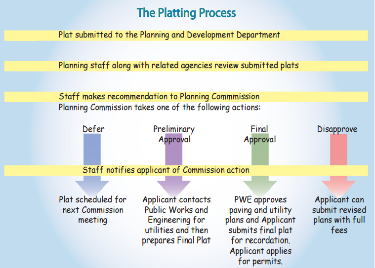
Platting Process
A plat provides for the subdivision of land that can be legally defined (i.e. Lot 5, block 12 of the Texans Fans subdivision). Subdivision plats are required to show how land will be subdivided. The plat must reflect adequate streets and right-of-way for the project. In the City of Houston the plat is checked to assure it abides by all development rules as established by Chapter 42, the City’s land development ordinance. By law, the Planning Commission is required to approve plats that meet the requirements of Chapter 42 such as:
- Undeveloped land must be platted before development occurs.
- If land is platted, it can be replatted to further subdivide the existing subdivision plat or change the use of the property (i.e. from single-family to multi-family). Typically, a replat will make changes to the layout of: lots, reserves, building setback lines and easements.
The process begins at the city level. The City of Houston illustrates the beginning of their process as follows:
Is a Survey Needed?
Almost all Plats require a new survey. For example, The City of Houston requires the following:
1. The Plat is prepared and signed by a licensed surveyor.
2. The Plat states that the surveyor preformed a survey of the property.
The only exception to this general rule is Amending Plats.
Types of Plats in Texas
General types of Plats:
- Preliminary Plat: This is a map of a more general nature for large scale development. This plat will typically only show the approximate areas of the lots and a rough layout of the streets. This may not be required for all projects.
- Final Plat: This becomes the official map filed at the county courthouse. This map precisely describes the property and gives the exact dimensions of the lots, streets, and easements of the property. Under state law, only a Registered Professional Land Surveyor can prepare this plat.
- Re-Plat: This is a special type of map prepared to change lot lines or other items shown on the original plat. This type of plat might be used to combine small lots into larger ones, move lot lines, or cut small lots out of larger ones.
- Subdivision Plat: A graphical presentation of a particular surveyed tract of land laying out street rights-of-way, lots and reserves, building setback lines, and easements which must comply with the development requirements of the City of Houston’s, Code of Ordinances, Chapter 42. These regulations, adopted by City Council, are intended to promote the safe, orderly and healthy development of the City and its extraterritorial jurisdiction. The approved map subsequently may be filed and recorded with the appropriate county clerk’s office as the official map of record for this property.
- Subdivision Re-Plat: Is simply a subdivision plat that further subdivides an existing subdivision plat. Typically, a replat will make changes to the layout of lots, reserves, building setback lines and easements.
- Vacating Plat:
(a) The proprietors of the tract covered by a plat may vacate the plat at any time before any lot in the plat is sold. The plat is vacated when a signed, acknowledged instrument declaring the plat vacated is approved and recorded in the manner prescribed for the original plat.
(b) If lots in the plat have been sold, the plat, or any part of the plat, may be vacated on the application of all the owners of lots in the plat with approval obtained in the manner prescribed for the original plat.
(c) The county clerk shall write legibly on the vacated plat the word “Vacated” and shall enter on the plat a reference to the volume and page at which the vacating instrument is recorded.
(d) On the execution and recording of the vacating instrument, the vacated plat has no effect.
- Administrative Plat: An administrative plat is a plat or replat* that is approved through an administrative action in certain circumstances without the review and approval of the Planning Commission, as allowed by the Texas Local Government Code and the Subdivision Ordinance. Administrative review is only applicable for plats of 2 lots or fewer, fronting on a previously dedicated street where no public improvements are necessary. *An administrative replat will still require a public hearing. Determination of whether a plat can be reviewed administratively will be made by the Department after plat submittal.
Classes of Plats in Houston
The following are the most common Classes of Plats in Houston:
- Class 1 Subdivision Plat (C1): is only for residential and either amends a previous plat or:
1. Creates no more than four (4) lots, each fronting on an existing street;
2. Does not require or propose the creation of any new street;
3. Does not require or propose the dedication of any easement for public water, wastewater collection or storm sewer lines; and
4. Is not a replat. There is a one time submittal process for class I plats. Class I plats are not very common.
- Class 2 Subdivision Plat (C2) & Subdivision Replat (C2R): is a subdivision plat that:
1. Does not require or propose the creation of any new street;
2. Does not require or propose the dedication of any easement for public water, wastewater collection or storm sewer lines; and
3. Can be a replat but does not require notification of adjacent property owners for replatting purposes. There is a one-time submittal process. A variance or a special exception may be sought with a Class II plat.
- Class 3 Plats include: Subdivision Final Plat (C3F) Class 3 Subdivision Preliminary Plat (C3P), Class 3 Subdivision Preliminary Replat (C3R) and Class 3 Subdivision Replat Public Hearing Notification (C3N): are required for subdivisions that require or propose the creation of any new street or the dedication of any easement for public water, wastewater collection or storm sewer lines.
1. A class III plat is also required for a vacating plat.
2. A Class III plat requires two submittals: a preliminary and a final. A variance or a special exception may be sought with a Class III preliminary plat/replat and all variance or special exception applications within the city limits require notification of adjacent property owners.
3. Objections from adjacent property owners should be raised during the preliminary platting process. A preliminary plat application can be filed on land that is being considered for purchase. In many cases, final purchase may depend on the outcome of the plat submittal.
- Other classes include: General Plan (GP), Street Dedication Plat (SP), Vacating Final (VF) and Vacating Preliminary (VP)
Public Hearings in Houston
The City of Houston’s municipal code, Sec. 42-70, sets the following: This division establishes the procedures for the review of applications for subdivision plats, development plats, general plans and street dedication plats. As provided in this division, the director is authorized to approve Class I plats and development plats that meet the requirements of this chapter. Only the commission is authorized to approve Class II plats, Class III plats, general plans, street dedication plats and any Class I plat or development plat that the director refers to the commission.
Therefore a Class I plat will require a public hearing if a variance is requested. Class II and Class III plats require approval of the Planning Commission.
Tetra Land Services will represent you at any public hearings required for your plat. If a variance is required for your plat we will handle all necessary forms and notifications. Public hearings require a mail out to nearby residents along with signs posted to announce the date and time of the hearing.
The Commission meets every other Thursday at 2:30 p.m. in City Hall annex chambers, 900 Bagby, unless otherwise posted. The agenda is posted three days in advance on the Department’s website at www.houstonplanning.com. Items on the agenda posted as consent are typically considered all in one grouping. Items considered separately include replats requiring a public hearing and variances. Members of the public can sign up to speak on any agenda item at the meeting. Speakers are allowed two minutes and can only speak once per item (if the item is deferred, speakers must choose at which meeting to speak).